The U.S.
Air Force started its first military space program in 1956. Known as
Weapons System 117L (or more simply, WS-117L), it was an effort to develop
a television-based reconnaissance satellite for spying on the Soviet
Union. The program limped along under funded until after the Soviet launch
of Sputnik, in October 1957, when it shifted into high gear. At this
point, the U.S. Air Force began developing two types of satellites. One
was a system, soon named Samos, that would take a picture on film and
develop it in orbit, scanning it like a computer scanner and relaying the
data to the ground over a radio link. This system was slow, and the
satellites could transmit only a few dozen images a day, which was too
little to have any value. The Samos readout system was cancelled in the
early 1960s.
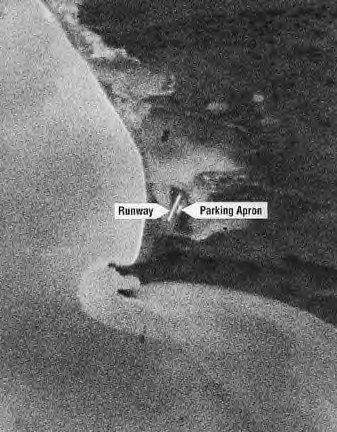
First imagery taken by CORONA -
Mys Shmidta Air Field, USSR 18 Aug 1960.
The
other system, which was led by the Central Intelligence Agency (CIA) with
substantial Air Force participation, was named CORONA in February 1958
(the names of U.S. intelligence satellites are always written in all
upper-case letters). This system used a panoramic camera on a stabilized
satellite to take a long, thin image on a 70-millimeter strip of film.
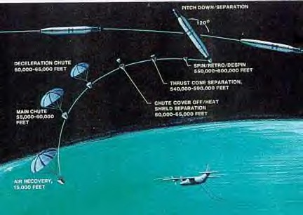
CORONA recovery sequence.
The
film wound on a reel inside a small bucket-shaped re-entry vehicle and
re-entered the atmosphere, where it was snatched out of the air by a
passing airplane while hanging from its parachute. CORONA could see
objects as small as six to nine feet (two to three meters) on a side. Only
the film was saved; each satellite was used for only a single mission. The
first successful mission was in August 1960 and more than 120 satellites
were launched until the early 1970s, when the system was replaced by a
much more massive satellite commonly referred to as the “Big Bird,” but
actually named the KH-9 HEXAGON.
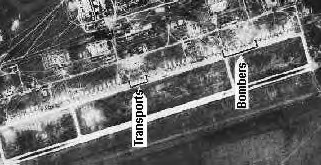
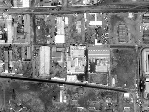
CORONA image showing transport
vehicles and bombers.
Beginning in 1960, the Air Force began developing a new, high-resolution
satellite system called the KH-7 GAMBIT. This satellite could take very
powerful images of a small area on the ground, allowing an intelligence
analyst to look at targets as small as 1.5 feet (0.5 meters) across. By
1967, an even more powerful version entered service, allowing experts to
see objects as small as about three inches. This was the most powerful
satellite ever operated by any nation, but it did not allow operators to
read license plates, like Hollywood satellites could.
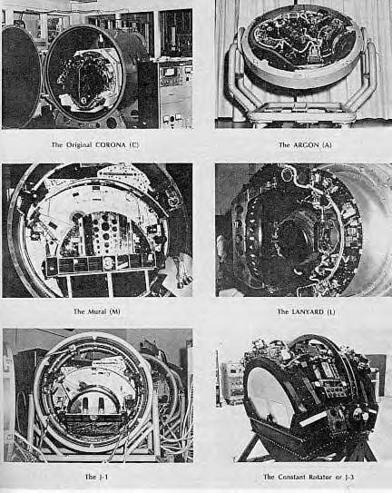
The CORONA cameras.
The
Soviet Union also started its own reconnaissance satellite program in the
late 1950s. This effort, known as Zenit, used a modified version of the
Vostok piloted spacecraft, equipped with several cameras that took still
images. The entire large re-entry vehicle would return to Earth with both
film and cameras, allowing the cameras to be reused. The Soviets also
developed a higher-resolution system called Yantar, versions of which are
still in use today.
After
Sputnik, the U.S. Navy began developing a small satellite for intercepting
Soviet radar transmissions. Several of these satellites, named GRAB, and
later DYNO, were launched starting in 1960 and followed by a better series
of satellites named POPPY. They intercepted the electronic signals emitted
by ground-based aircraft search radars, allowing the Navy and the Air
Force Strategic Air Command to locate the radar positions and develop ways
of avoiding or jamming them. A more capable system, called PARCAE, used
groups of small satellites. It could locate ships at sea based upon their
radar and radio transmissions by triangulating their position.
Starting
in 1961, all of these intelligence collection satellites were operated by
a highly secret agency within the Department of Defence called the
National Reconnaissance Office, or NRO. The NRO was not even publicly
acknowledged until 1992.
Throughout the 1960s, the United States and the Soviet Union operated much
bigger and better versions of their film-return satellites and signals
intelligence satellites. In the late 1960s the U.S. Air Force began
operating a communications intelligence satellite named CANYON that
intercepted Soviet telephone transmissions. Follow-on versions of this
satellite, named VORTEX and MERCURY, continued to operate into the 21st
century. In the early 1970s, the CIA deployed a satellite named AQUACADE
for intercepting the faint radio signals from Soviet missile tests, using
a giant mesh dish for detecting the electronic whispers. Modern versions
named MERCURY and ORION were launched in the 1980s, and even more upgraded
versions were launched in the 1990s. These satellites are believed to have
truly massive antennas that unfurl in geosynchronous orbit.
The one
major limitation of the film-return satellites like CORONA, HEXAGON,
GAMBIT and Zenit and Yantar is that it could take days for their images to
reach the eyes of an intelligence expert. Both countries investigated
whether piloted reconnaissance satellites could partly fulfil this role.
The U.S. Air Force's Manned Orbiting Laboratory (MOL) was designed to
assess the capabilities and potential of military operations in space but
was abandoned in 1969, before it ever flew. The Soviet Union launched
several Almaz military space stations during the 1970s before abandoning
its effort. Both countries realized that humans and sensitive optics were
a bad combination.
Throughout the 1960s both the U.S. Air Force and the CIA sought to develop
a “real-time” imaging satellite system that could transmit its images to
the ground as fast as it took them. The CIA sponsored the development of
what became the Charge Coupled Device, or CCD, like that used in modern
digital cameras. In December 1976, the NRO launched the first satellite
using this new technology, called the KH-11 KENNAN. The KH-11 allowed
images to reach an intelligence expert, or the desk of the President of
the United States, within minutes. It too revolutionized intelligence
collection and by the 1980s the United States no longer launched
film-return satellites. These satellites look much like NASA's Hubble
Space Telescope, with a large mirror inside a long tube, except they point
at the Earth rather than the stars. They can probably see objects about
the size of a softball. Versions of the KH-11 equipped with some infrared
capability (later called CRYSTAL and now called by some highly-secret code
name) continue to operate today and their images are vital to U.S.
military operations.
KH-11 photo of the Shifa
Pharmaceutical Plant, Sudan.
The
Soviet Union continued to lag behind the United States and did not orbit
its own real-time reconnaissance satellite until the 1980s. After the Cold
War ended, Russian military space launches diminished to a trickle and
they launched fewer reconnaissance satellites. Surprisingly, the Russians
still launch the occasional film-return satellite, possibly because their
real-time satellite, although fast, cannot take high-quality photos.
The
final major limitation to imaging satellites was clouds. In the 1960s, the
U.S. Air Force launched a radar satellite named QUILL, capable of peering
through clouds, but it could not see much detail. In the late 1980s, the
NRO launched the first of a new class of large imaging satellites, named
LACROSSE (and later ONYX). These satellites probably see images on the
ground about three feet (one meter) across.
China
also developed film-return satellites starting in the 1980s, and may have
a real-time reconnaissance satellite today. France led a consortium of
European countries during the 1990s and orbited its Helios reconnaissance
satellite. France has also sought to develop small signals intelligence
satellites as well. In the late 1980s, Israel launched its first imaging
satellite, called Ofeq, and has since followed with others. Other
countries, such as India, have also sought to develop a satellite
reconnaissance capability. But the emergence of commercial imaging
satellites in the late 1990s, capable of taking images of objects as small
as two feet (0.61 meter) across, means that a capability once available
only to the superpowers is now available to any country—or person—with a
credit card.
