|
operational remote sensing satellites
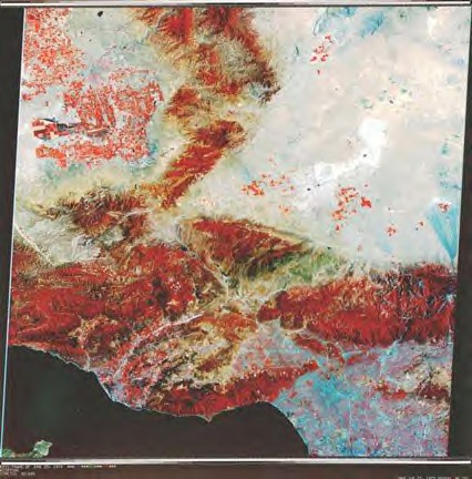
Landsat 1 mosaic of Southern
California, June 1974.
The
field of remote sensing took shape during the 1960s as an outgrowth of
aerial photography. New instruments, forming images in the infrared as
well as in visible light, produced “false colour” photos in which forests
and farms appeared red rather than green. They contained astonishing
amounts of information, and William Pecora, director of the U.S.
Geological Survey (USGS), took the lead in pushing for a spacecraft that
could cover the entire world with such images.
The first of them, Landsat
1, reached orbit in 1972, with four more following during the next dozen
years. Their photos showed where crops were infected with diseases such as
leaf blight. Geologists saw complete fault zones at a glance. Hydrologists
monitored the snowpack in mountains and forecast the availability of
water. Land use planners studied the spread of suburbs. In South America,
Landsat photos led to the first accurate maps of much of that continent.
In California, a single analyst took only a week to inventory 25 separate
crops across the entire state, noting how much of each was being grown.
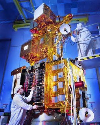
Landsat 7 satellite.
Landsat
was a program of the National Aeronautics and Space Administration (NASA).
In 1979, President Jimmy Carter transferred it to the National Oceanic and
Atmospheric Administration (NOAA), which already operated the Nation's
weather satellites. In 1983 President Ronald Reagan directed NOAA to place
the program in the hands of a private corporation. The Land Remote-Sensing
Commercialization Act of 1984, enacted by Congress, gave guidelines for
this transfer. However, a problem quickly emerged: the need for federal
subsidies.
Within
the national economy, the information from Landsat had a value as great as
$10 billion per year. This was quite enough to justify a remote-sensing
program with an annual budget in the hundreds of millions, to cover the
cost of developing new instruments and spacecraft. But the main source of
income for such a program appeared to lie in sales of photos and images,
which could bring in as little as $6 million per year. Studies showed that
subsidies of up to $500 million were therefore required, to be spread over
several years.
The
Reagan administration did not like subsidies and cut the offer to $250
million. On this basis, only one company remained willing to bid for
NOAA's Landsats, and it took over the program. This was Eosat, a joint
venture between the satellite manufacturer Hughes and the electronics firm
RCA. This firm was to operate Landsats 4 and 5, which had reached orbit
respectively in 1982 and 1984; build two new satellites, Landsats 6 and 7;
and hold exclusive rights to market photos and other data.
Events
soon showed that while individual analysts placed great value on the
Landsat images, no one in Washington had the influence to win support for
the program at high levels of government. Even at reduced levels, the
subsidy payments proved hard to come by. Eosat did what it
could—quadrupling the price of its photos, collecting fees from overseas
stations that received the satellite data—but still found itself surviving
on a financial shoestring. Work on Landsat 6 went ahead, slowly, but the
company limped from one financial crisis to the next.
By
contrast, the French had no qualms about subsidies. Their government
launched the SPOT program, the Satellite Pour l'Observation de la Terre,
in 1978 and in 1982, established the firm of SPOT Image, to market its
photos. The first spacecraft flew to orbit in 1986 and quickly showed that
its photos had superb quality. In Washington, the Pentagon had issued
rules to prevent Landsat images from having military value, but these
regulations did not apply in France. News organizations soon found that
SPOT was ready to serve as a reconnaissance satellite for use by the
press.
Meanwhile, as Eosat stumbled along, it became increasingly clear in
Washington that the market for a commercial Landsat still was far from
ripe. A new law, the Land Remote-Sensing Policy Act of 1992, repealed the
1984 law and returned Landsat to the government. Matters came to a head in
October 1993 when Landsat 6 failed in its launch attempt, underscoring the
need for Landsat 7.
Decisions during 1994 sorted out the responsibilities. Eosat continued to
operate Landsats 4 and 5 and retained the right to sell their photos. NASA
took responsibility for building Landsat 7, with NOAA agreeing to operate
this spacecraft in orbit. The USGS took over the task of marketing its
data, while maintaining an archive of photos for sale to customers.
In this
fashion, the 1992 law laid solid groundwork for Landsat 7, which reached
orbit in 1999. By then it had company. The 1992 law arranged for the
licensing of true commercial remote-sensing satellite systems, which took
shape during subsequent years. Lockheed was the first company to obtain
such a license, winning federal approval for its Ikonos satellite in 1994.
Other systems followed: Orbview of Orbital Sciences, Quickbird for the
firm of DigitalGlobe.
These
spacecraft have saved money by being lighter than Landsat 7's 4,780 pounds
(2,168 kilograms). Several of them have also broadened their markets by
providing photos with a sharpness that the Central Intelligence Agency
might have envied. The Ikonos craft have used both approaches. Its license
endorsed a Lockheed plan for resolution of one meter; that is, the ability
to show objects as small as one meter in the photos. Ikonos 1, with
one-third the weight of Landsat 7, flew to orbit in September 1999. Its
colour images of Manhattan, taken from an altitude of 423 miles (681
kilometres), were so crisp that they showed cars on the city's highways.

SeaWiFS is carried aboard the
satellite OrbView-2, providing
important information about the oceans and the life within them.
Orbital
Sciences has pursued a step-by-step approach. Its first satellite, Orbview
1, went into orbit in April 1995. It was a weather satellite that returned
black-and-white images. Orbview 2, in August 1997, was a true
remote-sensing craft with only one-seventh the weight of Landsat 7. Its
photos covered broad swaths of land and sea, but lacked detail. However,
Orbview 3, currently planned for launch, is to match Ikonos by providing
its own one-meter resolution.
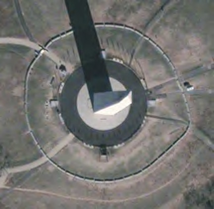
Quickbird image of the Washington
Monument. Image courtesy of DigitalGlobe
Quickbird, which flew in October 2001, currently is doing even better. Its
photos show detail as small as two feet in size. Its images can cover more
than three times the area of North America in the course of a year, while
its spacecraft weighs less than half as much as Landsat 7.
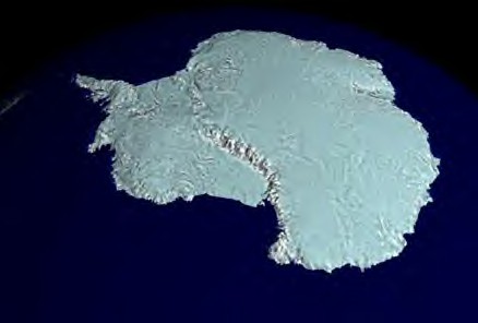
For 18 days during the Southern
Hemisphere spring of 1997,
a NASA-launched Canadian satellite called RADARSAT collected pieces of a
puzzle
that will help scientists study the most remote and inaccessible part of
the Earth -- Antarctica.
Scientists now have the puzzle pieces put together,
forming the first high-resolution radar map of the mysterious frozen
continent.
Other
nations have built their own operational remote-sensing satellites.
Canada's Radarsat, launched in 1995, forms its images by using radar
instead of visible light. It thereby operates at night as well as in the
daytime, while its radar beams pierce through clouds. An Argentinian
spacecraft, the Scientific Applications Satellite or SAC-C, carries
remote-sensing equipment along with other instruments. Launched in
November 2000, its tasks include determination of the migration route of
the Franca whale.
In Asia,
South Korea has pursued a program resembling that of Orbital Imaging. That
country started in 1992 and 1993 with two small spacecraft, each weighing
about a hundred pounds. The program, called Uribyol or Our Star, has
doubled its weight with its third satellite, which flew in 1999. This
project is important; it shows how small a remote-sensing spacecraft can
be while still returning useful data.
Moreover, China and India have not only built their own remote-sensing
craft but have orbited them using their own launch vehicles. The Indian
Remote Sensing program has been particularly active, flying its first
spacecraft in 1988, aboard a Soviet rocket and continuing since 1994 with
India's own Polar Satellite Launch Vehicle. The newest craft, called
Oceansat, flew in 1999, and only a few months later, surveyed the damage
done by a powerful typhoon.
China
has entered this field more recently, but its Ziyuan craft flew
successfully in 1999 and 2000. In contrast to the lightweight satellites
of South Korea, these tip the scale at more than a ton and a half. Both
reached orbit aboard a new rocket of the Chinese-built Long March series.
Remote
sensing began in the United States and France, but today an increasing
number of nations in the Third World are involved in these programs.
Brazil cooperated with China in building Ziyuan 1, Brazil also is
developing its own launch vehicle. A spacecraft for Thailand, the Thai
Microsatellite, resembles the early Uribyol craft of South Korea and flew
in 1998. Such nations are unwilling to purchase photos from America or
France; they want images that are all their own.
|
