|
meteorological satellites
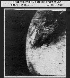
The first television picture
from space, produced on TIROS 1, April 1, 1960.
Beginning in the early 1960s, meteorological, or weather, satellite
programs have been an important focus of government agencies. In the
United States, the National Aeronautics and Space Administration (NASA),
the National Oceanic and Atmospheric Administration (NOAA), and the
Department of Defence (DoD) have all been involved with developing and
operating weather satellites. In Europe, the European Space Agency (ESA)
and EUMETSAT (European Organisation (the European spelling for
“Organization”) for the Exploitation of Meteorological Satellites) operate
the meteorological satellite system.
The
world's first weather satellite, a polar-orbiting satellite, was launched
from Cape Canaveral, Florida, on April 1, 1960. Named “TIROS” for
Television Infrared Observation Satellite, this was NASA's first
experimental step to determine if satellites could be useful in the study
of the Earth and whether they could continue operating for an extended
period of time. The series proved extremely successful, with one satellite
operating for almost five years and several operating more than three
years.
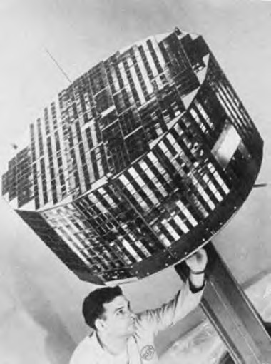
Making adjustments to TIROS II
satellite prior to launch. Small square objects are 9,260 solar cells.
TIROS II was the first meteorological satellite to have infra-red sensors
as well as television cameras.
It was launched November 23, 1960 and weighed 280 pounds.
An
operational system of meteorology satellites flying in low-Earth orbit
(about 450-470 nautical miles [833-870 kilometres] altitude) began
operating in 1970. These satellites were called the Improved TIROS
Operational System (ITOS) at launch and NOAA once they were checked out
and became operational. The primary objective of this series of
sun-synchronous satellites was to provide improved infrared and visual
observations of Earth cloud cover for use in analyzing weather and
forecasting. Other objectives included measuring snow and ice and the sea
surface, and gathering information on the vertical structure of
temperature and moisture in the atmosphere on a regular daily basis. Six
of the eight satellites in this series were launched and operated
successfully, with one operating more than four years.
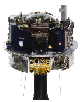
A military weather satellite of
the mid-1960s from Program 417, predecessor to the
modern Defense Meteorological Satellite Program, designed for the National
Reconnaissance Office.
NASA's
Nimbus satellites were flown from 1964 through 1978, as advanced research
satellites that tested new sensing instruments and data-gathering
techniques rather than as operational weather satellites. The
Environmental Science Services Administration (former name for the
National Weather Service), however, did become a routine user of Nimbus
data. This data was valuable for its coverage of conditions over oceans
and other areas where few other upper atmospheric measurements were made.
Instruments on the Nimbus satellites included microwave radiometers,
atmospheric sounders, ozone mappers, the Coastal Zone Colour Scanner, and
infrared radiometers and provided significant global data on sea-ice
coverage, atmospheric temperature, atmospheric chemistry (i.e., ozone
distribution), the amount of radiation in the Earth's atmosphere, and
sea-surface temperature. The Total Ozone Mapping Spectrometer (TOMS)
instrument aboard the final Nimbus, Nimbus-7, mapped the extent of the
phenomenon known as the “ozone hole.”
The
first series of TIROS satellites was followed by a series that began with
the October 1978 launch of TIROS-N, an experimental spacecraft that served
as a model for the operational follow-on series: NOAA-6 through NOAA-17.
The technological improvements integrated into this series of satellites,
the current ATN or Advanced TIROS series (the launch of NOAA-17 is planned
for 2004), have provided higher resolution images, and more day and
night time data for both local and global areas than the earlier series.
Polar-orbiting satellites can collect data for almost the entire Earth,
and when two operate simultaneously, as this system is designed,
environmental data for any region of the Earth is collected at least twice
every 12 hours. This series of satellites has experienced only one launch
failure, and almost all of the satellites have greatly exceeded their
two-year expected lifetime. NOAA-8, launched in March 1983, was the first
to carry search and rescue transponders. This international humanitarian
system, with 29 participating nations, allows aircraft, ships, and people
in distress who carry transmitters or beacons to signal the satellite,
which then transmits the signal to a terminal on the ground where rescue
operations begin. As was true with the earlier satellites, NASA is
responsible for development, launch, and checkout of the satellites. Once
operational, NOAA operates them.
Geosynchronous weather satellites provide a different type of coverage.
Flying in orbit some 22,400 miles (35,790 kilometres) above the equator, a
pair of satellites provides the continuous day and night time monitoring of
almost an entire hemisphere necessary for intensive data analysis. NASA
launched the first geosynchronous meteorological satellite (SMS-1) on May
17, 1974, from Cape Canaveral Florida. GOES-1, launched on October 16,
1975, was the first of the Geostationary Operational Environmental
Satellites (GOES). It formed part of a two-satellite constellation that
viewed nearly 60 percent of the Earth's surface. Twelve more GOES have
been launched since, with only one launch failure. GOES-7, launched in
1987, inaugurated the use of geosynchronous satellites for international
search and rescue efforts. The search and rescue system became operational
with GOES-8, which was launched in 1994.
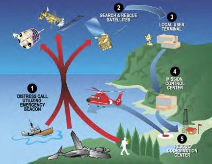
The international satellite-based
search and rescue system makes use of equipment carried on
U.S. polar-orbiting and geosynchronous meteorological satellites and on
Russian satellites.
GOES-8
was the first satellite to use three-axis stabilization rather than spin
stabilization, which resulted in significant improvements in gathering
weather imagery and atmospheric data. It also was the first to carry
separate instruments that captured images and that atmospheric data at the
same time. These instruments, called Imager and Sounder, have been the
primary instruments aboard the satellites. They enable researchers to
gather data continuously without having to alternate between using two
operating modes on a single instrument. The newest GOES can also use the
Global Positioning System for search and rescue operations to locate
distress signals precisely, resulting in much better response time for
providing rescue assistance. GOES-12, launched on July 23, 2001, was also
the first to carry a solar x-ray imager, an instrument that points toward
the sun rather than the Earth and observes the sun's x-ray emissions,
providing early detection and location of solar flares. As with the
polar-orbiting satellites, NASA manages development, launch, and checkout
of these satellites and then turns them over to NOAA for operation.
NOAA
also currently operates the Defence Meteorological Satellite Program (DMSP),
a near-polar-orbiting series of satellites initiated by the Defence
Department in the mid-1960s and the responsibility of the U.S. Air Force.
Each DMSP satellite, orbiting at approximately 516 miles (830 kilometres)
above the Earth, crosses any point on the Earth up to twice a day. They
see such environmental features as clouds, bodies of water, snow, fire,
and pollution in the visual and infrared spectra. Scanning radiometers
record information that can help determine cloud type and height, land and
surface water temperatures, water currents, ocean surface features, ice,
and snow. Communicated to terminals on the ground, the data is processed,
interpreted by meteorologists, and used in planning and conducting U.S.
military operations worldwide.
The
earliest DMSP satellites were 90-pound (41-kilogram) spin-stabilized
satellites equipped with shutter-style TV cameras. The photos obtained
were relayed to Earth and received by two stations at retired Nike missile
sites in Washington and Maine. The photos were then sent to Air Force
Global Weather Central at Offutt Air Force Base, Nebraska, where
technicians would transform the electronic signals into Polaroid
photographs and piece the photos together to form a mosaic that
represented the weather observed from the orbiting satellite.
Meteorologists then provided flight crews and commanders with current
observations for their missions. These older spacecraft encountered
problems with gaps in the photos and errors in storm location caused by
the inability of the satellites to point accurately toward their target.
Better
spacecraft technology in the 1970s resulted in improved optics, signal
processing, and larger payloads. Gaps in the photos were eliminated, and
meteorological data could be gathered near the horizon, allowing
meteorologists to see “around the bend.” Further advancements allowed data
to be collected in partial moonlight, and infrared processing enabled
night viewing. The late 1970s and early 1980s, saw improvements in
attitude control (the direction in which the spacecraft pointed) and
increased onboard processing through the use of multiple onboard
computers. With the enhanced equipment on board, DMSP satellites currently
weigh more than 1,400 pounds (635 kilograms).
On May
5, 1994, President Bill Clinton decided to merge America's military and
civil polar-orbiting operational meteorological satellite systems into a
single, national system that could satisfy both civil and national
security requirements for space-based environmental data. Called the
National Polar-orbiting Operational Environmental Satellite System (NPOESS),
it is estimated that the first converged satellite will be available for
launch toward the end of the first decade of the 21st century.
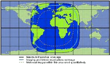
The coverage area of Meteosat at
0ø longitude.
The
European meteorological satellite system is called Meteosat. First
proposed by the French national space agency Centre National d'Etudes
Spatiales (CNES), in 1969, eight member nations of the European Space
Research Organization (ESRO), the predecessor to ESA, decided in 1972 to
finance the effort. On November 23, 1977, Meteosat-1 was launched from
Cape Canaveral, Florida. Meteosat-2 followed in June 1981, launched from
Kourou, French Guyana, as were all later Meteosat satellites. The most
recent satellite, Meteosat-7, was launched in 1997. Currently, EUMETSAT
and ESA are cooperating on the production of a completely new system to
take over and significantly improve the operational service by 2003. This
will be accomplished through the Meteosat Second Generation group of
satellites. (EUMETSAT, Europe's meteorological satellite organization, is
an intergovernmental organization created through an international
convention agreed to by 17 European member states.)
|
