aircraft
navigation technology
The Sperry Messenger airplane had gyroscopic equipment installed in its
fuselage section
to control its attitude and direction of flight.
Later refinements of gyro controls led to the development of airplane
autopilots.
Early pilots looked out of their open cockpits for
roads, rail lines, and airports to find their way in daytime flight.
Pilots watched the horizon to make sure they were flying with the
aircraft's nose and wings in the proper position relative to the ground,
called attitude. As airmail pilots began flying at night and in all kinds
of weather in the early 1920s, new equipment helped pilots navigate and
maintain aircraft attitude when they could not see the ground. Navigation
aids were developed for use inside the aircraft and also to guide the
pilots from the ground.
Simple equipment to help pilots maintain attitude was
introduced during the 1920s. These devices included such ideas as a bubble
of liquid to help keep wings level and a device that measured pressure at
different heights, called an altimeter, that told a pilot his altitude
above ground level. A simple magnetic compass for direction was installed
either in the cockpit panel or held in the pilot's hand.
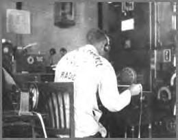
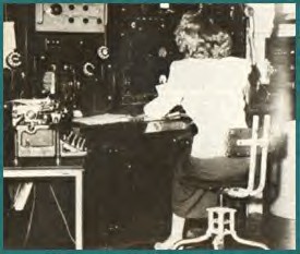
The interior
of the Airway Radio Station at Portland, Oregon, about 1929.
Carl Anderson examines a strip of the code in which the station operators
made most of their transmissions during this period.
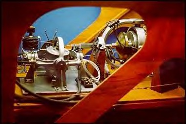
In 1929, Lawrence Sperry and his Gyroscope Company
introduced important new technology—the Artificial Horizon—that operated
on gyroscopic principles. With its sensitive attachments, Sperry's device
could detect forces that upset the gyroscope's stable spin, then would
activate the aircraft controls to maintain proper attitude while flying
when visible flight was not possible.
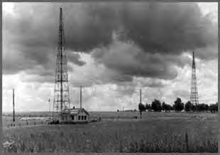
The St. Louis
Airway Radio Station during the late 1920s or early 1930s is shown.
Barely visible in the photo is the wire strung between the tops of its
twin antenna towers.
During this era, some stations were making hourly weather broadcasts.
In the 1930s, new mechanical aids emerged, some based
on Sperry's gyroscope and others based on the rush of air through intakes
under the wing or the aircraft belly to measure speed and altitude.
Equipment outside the aircraft measured the velocity of the air as it
entered one intake and exited another. The results were fed to the pilot
to help him determine the aircraft's attitude and position.
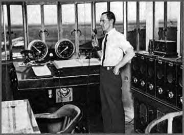
In 1930,
Cleveland Municipal Airport established a radio-equipped airport control
tower.
In the next five years, about 520 cities followed Cleveland's lead.
Controller Bill Darby is shown with the latest equipment in this 1936 view
of Newark tower.
Navigation information was displayed on a group of
instruments called the basic or primary six, which included the attitude
indicator, a vertical speed indicator showing the rate of climb and
descent, airspeed indicator, turn-and-bank coordinator, a heading
indicator showing the magnetic compass course, and the altimeter. These
instruments are still used.
Refined versions of Sperry's invention appear in 2001
as the Inertial Navigation System (INS) and the Inertial Guidance System (IGS).
These systems measure changes in the aircraft's location and attitude that
have taken place since the aircraft left the ground. These new devices
include an accelerometer to detect changes in airspeed as well as
attitude. By determining the precise latitude and longitude before flight,
then tracking every change in location, the INS or IGS tells the pilot
where he has flown.
Radio navigation aids were developed around the same
time as mechanical aids. In 1926, successful two-way radio air-to-ground
communication began, and the first transmitter/receiver went into mass
production in 1928. Teletype machines were installed so that all stations
along an air route could transmit weather conditions to the pilot.
Eventually the pilot used these stations to indicate the plane's location.
The earliest radio navigation aid was the four-course
radio range, which began in 1929. Four towers set in a square transmitted
the letters A and N in Morse code. A pilot flying along one of the four
beams toward the square would hear only an A or N in the dashes and dots
of the code. The dashes and dots grew louder or more faint as he flew,
depending if he was flying toward or away from one of the corners. Turning
right or left, he would soon hear a different letter being transmitted,
telling him which quadrant he had entered.
The beams flared out, so that at certain points they
overlapped. Where the A or N signals meshed, the Morse code dashes and
dots sounded a steady hum, painting an audio roadway for the pilot. At
least 90 such stations were in place by 1933, about 200 miles (322
kilometres) apart along the 18,000-mile (28,968-kilometer) system of
lighted towers and rotating beacons. Unfortunately, mountains, mineral
deposits, railroad tracks, and even the atmospheric disturbance of the
setting sun could distort the signals.
The first radio-equipped airport control tower was
built in Cleveland, Ohio, in 1930, with a range of 15 miles (24 kilometres).
By 1935, about 20 more towers had been erected. Based on pilot radio
reports, a controller would follow each plane with written notes on a
position map. The controller would clear an aircraft for takeoff or
landing, but the pilot still could decide on the best path for himself.
Until World War II, radio navigation relied on low
frequencies similar to those of an AM radio. Devices such as the automatic
direction finder and the non-directional beacon, like the 1920s system
before them, used Morse code, and the detection of weaker to stronger
volume let a pilot know if he was on course. After the war, higher
frequency transmitters, called the very high frequency omni-directional
radio range or VOR, further refined the early concept of allowing pilots
to fly inbound or outbound along a certain quadrant on a line called a
radial. These transmitter locations, their frequencies and identifying
Morse codes are all printed on navigation charts. The various radio-based
systems are sufficient for navigating between airports but are called
non-precision aids because they are not accurate en ough and do not provide
enough information to allow a pilot to land.
Around 1940,
the evolving facilities were known as Interstate Airway Communication
Stations (INSACs).
Women often staffed the stations, particularly during the World War II
era.
Before World War II, the Civil Aeronautics
Administration relied on pilots to radio their position relative to known
navigation landmarks to keep the aircraft safely separated. During the
war, radio detection and ranging (RADAR) was tested. Radar's primary
intent was, and still is, to keep airplanes separated, not to guide them
to a specific point.
In 1956, a TWA Lockheed Super Constellation with 64
passengers and six crew and a United Airlines DC-7 with 53 passengers and
five crew collided over the Grand Canyon, killing all 128 people. The
incident led to new federal funding for rapid development of radar, air
traffic control procedures, and technologies for more precise navigation.
The crash also led to an aviation agency reorganization that included
creation of the Federal Aviation Agency.
Today's aircraft are tracked as computer-generated
icons wandering across radar display screens, with their positions,
altitude, and airspeed updated every few seconds. Pilots and controllers
communicate using both voice and data transmitting radios, with
controllers relying on radar tracking to keep aircraft on course. Today,
cockpit navigation information is increasingly displayed on a monitor, but
the position of information and its format are nearly identical to the
basic six instruments of early and simpler aircraft.
New technologies, though, have led to a debate as to
whether the federal government, using fixed electronic stations, or the
pilots should control navigation like in the earliest days. The global
positioning system (GPS) is one technology that allows pilots to
accurately determine their position anywhere on the Earth within seconds,
raising the question whether they need any help from the ground.
GPS is becoming the primary means of navigation
worldwide. The system is based on satellites in a continuous grid
surrounding the Earth, each equipped with an atomic clock set to
Greenwich, England, called ZULU time. The GPS units in the aircraft, or
even in a pilot's hand, find the nearest two satellite signals in a
process called acquisition. The time it takes for the signals to travel
creates a precise triangle between the two satellites and the aircraft,
telling the pilot his latitude and longitude to within one meter or a
little more than one yard. In coming years, this system will be made even
more precise using a GPS ground unit at runway ends.
Despite these advances, pilots can still crash because
they get lost or lose track of hazards at night or in bad weather. On
December 29, 1970, the Occupational Safety and Health Act came into
effect. It requires most civilian aircraft to carry an emergency locater
transmitter (ELT). The ELT becomes active when a pilot tunes to an
emergency radio frequency or activates automatically when the aircraft
exceeds a certain force in landing, called the g-force, during a crash.
This form of navigation aid, which transmits signals to satellites
overhead, saves lives of injured pilots and crew who are unable to call
for help themselves.
|
